The Meetjesland in the north of East-Flanders, Belgium
Aalter
There is no agreement on the etymology nor on the meaning of the name Aalter. Old forms of it are Haltra, Haleftra, Haltre, Haelter and Haeltert. It is only from the 1700's on that Aeltre becomes the name used by most.
 Aalter is situated in a green leafy region midway between
Bruges and Ghent and central also between Eeklo
and Tielt-Deinze. The better part of the center of Aalter lies about 20 yards
above sea level.
Aalter is situated in a green leafy region midway between
Bruges and Ghent and central also between Eeklo
and Tielt-Deinze. The better part of the center of Aalter lies about 20 yards
above sea level.
Archaeological finds of the last 40 years prove that humans lived here already in prehistory. A couple of paleolithical sites with numerous stone and flint artefacts were uncovered. These date from 3000 to 2000 years BC. A small bronze axe was also found. Archaeologists claim it was made between 1200 and 1000 years before Christ. The Oostergem cemetery dates from the late Bronze or early Iron Age. People also lived here during the Gallo-Roman Period.
The earliest mention of the name Aalter was in 974. Near the actual church, more or less where we now have the market place there was then a "Villa Haleftra" surrounded by its fields. The work on these fields was done by bond men who belonged to the farm. Later on, the "Boomgaard" (Orchard) was a small part of the "Hof van Praet" ("hof" = farm). This Hof belonged to the Seigneurs of Aalter, also called Seigneurs "van de Woestijne" ("woestijn" = desert, waste land). "Van Praet" and "Van de Woestijne" are now family names. The Seigneur used to have his "huus", house, further north. In 1546 the then Seigneur of Aalter, Louis van Praet, had his house built here. Around 1590, during the religious troubles, the Hof van Praet and the entire town including the house of God were burned to the ground by Dutch freebooters but the great farm was never rebuilt.
 In the Middle Ages the "Bulskampveld" was
the largest heath in Flanders. There were innumerable ponds and lakes.
The Kraenepoel ("poel" = pond) is the only one that remains to this
day. Aalter was on the border of this great region of heath and woods that
stretched from Bruges to Ghent in the Middle Ages. The Kraenepoel survived
thanks to Jacob Lieven van Caeneghem, a textile baron who bought the abandoned
domain of Bellem in 1808. The Kraenepoel
was no more than a low lying area of the heath. He had a dam built around it
and that's how it became a lake. He stocked it with fish which he could
harvest a couple of years later simply by piercing the dam.
In the Middle Ages the "Bulskampveld" was
the largest heath in Flanders. There were innumerable ponds and lakes.
The Kraenepoel ("poel" = pond) is the only one that remains to this
day. Aalter was on the border of this great region of heath and woods that
stretched from Bruges to Ghent in the Middle Ages. The Kraenepoel survived
thanks to Jacob Lieven van Caeneghem, a textile baron who bought the abandoned
domain of Bellem in 1808. The Kraenepoel
was no more than a low lying area of the heath. He had a dam built around it
and that's how it became a lake. He stocked it with fish which he could
harvest a couple of years later simply by piercing the dam.
Aalter played an important role in the revolt of Ghent against the duke. In 1379 the White "Kaproenen" defeated here the Bruges canal diggers.
The digging of the Bruges Canal from 1613 till 1623 in the bed of the Durme river was very important for the development of the town. Along the canal quite a few fortresses were built to protect the country against the Dutch. The first bridge in Aalter dates from 1775. And in 1838 a railway line was built.
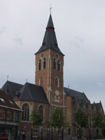
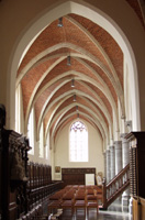
 In
1918 the upper part of the spire of the Saint-Cornelius Church was dynamited by
retreating German troops. This also did a lot of damage to the roof.
The church had been extensively rebuilt and enlarged in 1903. This 1918
war damage was repaired from 1921 to 1923 mostly according to architect Camille
Goethals' (neo-Gothic) plans of 1902. The earliest parts of the church go
back to the 12th or 13th Century.
In
1918 the upper part of the spire of the Saint-Cornelius Church was dynamited by
retreating German troops. This also did a lot of damage to the roof.
The church had been extensively rebuilt and enlarged in 1903. This 1918
war damage was repaired from 1921 to 1923 mostly according to architect Camille
Goethals' (neo-Gothic) plans of 1902. The earliest parts of the church go
back to the 12th or 13th Century.
In the 1930s began the construction of the motorway between Brussels and Ostend with an exit at Aalter.
 The town was liberated in 1944 by Polish soldiers. In Ter Walle there is a
monument to honour them. The Polish suffered so much during the Second World
War and at the end of it they were betrayed by the great Western powers.
With the agreement of the U.S., France and the U.K. not only was Poland moved
westwards which meant great parts of eastern Poland were given to arch-criminal
Stalin but the Polish people were then subjected to a long period of cruel Soviet
domination. Here
we have a little something by Mr. T. Stachowski about the Katyn Forest massacre.
The town was liberated in 1944 by Polish soldiers. In Ter Walle there is a
monument to honour them. The Polish suffered so much during the Second World
War and at the end of it they were betrayed by the great Western powers.
With the agreement of the U.S., France and the U.K. not only was Poland moved
westwards which meant great parts of eastern Poland were given to arch-criminal
Stalin but the Polish people were then subjected to a long period of cruel Soviet
domination. Here
we have a little something by Mr. T. Stachowski about the Katyn Forest massacre.
In 1962 an industrial site of more than 125 ha (about 310 acres) was created between the Canal and the town center. One of the firms there is the very well known and highly respected Lima Food.
The Old Canal, an old piece of the canal that before WW II was cut off from the Bruges-Ghent Canal is a delight for hikers, nature lovers and fishers. It is an officially protected landscape since 1977.
Our source for most of the above is the excellent "Streekgids Meetjesland", 1998, 104-107. See also: Our Sources.
Aalter is 4,635.4 hectares (nearly 11,450 acres). According to the official website of Aalter on 1 January 2004 there were in Aalter-Center 10,798 inhabitants and in Aalter-Brug ("Brug" = bridge) there were 1,019 inhabitants.
Greater Aalter, as we call these new mega-towns here, is the result of the merger since 1 January 1977 of the towns of Aalter (described here on this page), Bellem, Lotenhulle and Poeke.
Greater-Aalter is the first Belgian town to adopt the Digital City concept launched recently (2006) by some American company called Microsoft. We hear of claims that this digitizes and at the same time optimizes the services the town provides.
On the one hand it is supposed to put all the information at the fingertips of the town administrators and civil servants thanks to a thing called an interface whereupon they can follow the necessary instructions.
And on the other hand all this is supposed to bring the townhall to the people. Via the Aalter website and armed with their electronic ID card the good people of Aalter can communicate securely with their town hall. The civil servant on the other side of the virtual bullet proof glass is sure who he is dealing with thanks to the eID card. It all means Aalter now has an..., eh well in NewSpeak, an ISO-9001 certificate... Or is that a virtual certificate ?
And all this was realized by burgomaster Pieter De Crem whose office, reliable sources inform us, is sometimes jokingly referred to as the "Cremlin".
Meanwhile Aalter's fame is growing fast and worldwide thanks to a local girl. Evelien Bouilliart was born in Aalter on 30 January 1990. She started skateboarding when she was 10 years old. At the time there were practically no girls on the skateboarding circuit in Belgium but that made no difference to her. She became world famous in 2005, when she won the Mystic Cup in Prague and the Girls Push Jam in Munich. She came second that same year in the X-Games. If all goes well she'll soon be the world skateboarding champion. Her stunts on that skateboard are absolutely flabbergasting.
Aalter is officially twinned with Rotenburg (between Hamburg and Bremen) in Germany and with La Creuse (50 km north of Limoges) in France.

More pictures
Our Meetjesland
— Table of Contents
— Find something in this Meetjesland website

MijnPlatteLand.com
Most recent update : 05-03-2023
Copyright Notice (c) 2026